Oermingen The village is located in the Canton of Sarre-Union in the north-eastern region of Alsace-Bossue.
Oermingen is the last village in the valley Eichel before it flows into the Saar to 3.5 km downstream.
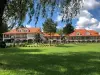
The village lies on both sides of the River.
The geological foundation of the ban include communal east and south-west of the clay-limestone on the east there are alluvial terraces and loess on the foundation of the upper Muschelkalk. The south-west and north of communal ban is covered by forests Timber Meyerwiese and Heidenwal.
The river system that supplies the territory of the municipality is composed of small streams as the Tiefgraben and Malschbach, which are tributaries of the Eichel.
The name of the village Oermingen appears for the first time in the 12th century in a charter sharing between Matthew 1st Duke of Lorraine and noble about regional boundaries of areas located in the Valley Echeil.
Orchigen called in 1125, the village appears again in a treaty of 1260 under the name of orming (Doc: Archives of Vienna, Appendix VII).
But human settlement on the area is much older. Significant archaeological discoveries of the Middle Paleolithic are reported on the municipal ban from the late 19th and early 20th century (R. Forrer 1926).
In 1936 major infrastructure masonry that belonged to parts of dwellings in a large old field were unearthed at a place called Bussmauer (V. Rusch 1937).
Before and after the Second World War many discoveries related to prehistory and the High Middle Ages were made around the village.
The archaeological surveys and chance discoveries of the past 30 years have identified a high density of sites with the chronology of occupations ranging from Mesolithic to the early history and antiquity to the medieval period (E. Thomann, P. Nüsslein 2000 ).
The town hall, a magnificent edifice of Late Renaissance, built in 1610 with two-sided oriel window spandrels decorated with motifs of metalwork first serves seigneurial court and a grain market and imprisonment.
The Protestant church in baroque style single nave with a choir wearing a three-sided shelters along widths organ Verschneider 1828. Built between 1775-1776 by architects Frederick Joachim Stengel and Karl Abraham Dodel to end sectarian strife between Catholic and Protestant linked to the only occupation of the single village church.
The church was rebuilt in 1819-1824 St. Remi at the site of a Romanesque building alongside the oldest Protestant sanctuary. The tower 42 meters high will be completed in 1871. Since 1979 she has an organ Koenig Sarre-Union.
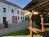
Like most villages in the valley Eichel Oermingen is distinguished by the architectural quality of its doorways carved in sandstone that are normally found in urban settings.
Restored and reclaimed by important heritage work undertaken by the town, these buildings have benefited from development by providing a large floral that has won the award in 2010 in the town of a second flower.
Every year the first weekend of August thousands of visitors converge Oermingen to participate in one of the greatest gastronomic events of Alsace-hunchback, the feast of onion.
During two days, more than 300 volunteers are on the go to serve over 6,000 meals prepared from recipes with onions, as onions stuffed with onion soup, onion tarts, the fritters and onion jam ... !
The great path of Saarland, who has Treves (Saarwanderweg) crosses the communal forest from Herbitzeim.
On this axis distance walks are grafted several trails established by the CV that link the forests and the banns communal villages Oermingen, Voellerdingen, Herbitzeim, Keskastel and Sarre-Union (see trail map 1 / 25 0000 2613 - Sarreguemines - Valley of the Saarland).


")