
Favourite
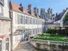
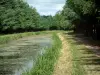
Berry Canal
| Municipality | Marmagne |
|---|---|
| Postcode | 18500 |
| Tourism label | ") |
| Latitude | 47.1017070 (N 47° 6’ 6”) |
| Longitude | 2.2840430 (E 2° 17’ 3”) |
| Altitude | From 113m to 149m |
| Surface area | 37.66 km² |
| Population | 1969 inhabitants |
| Density | 52 inhabitants/km² |
| Prefecture | Bourges (11.4 km, 17 min) |
| Insee code | 18138 |
| Intercommunality | CA Bourges Plus |
| Department | Cher |
| Territory | Berry |
| Region | Centre-Loire Valley |
| Berry-Bouy | 1.4 km (3 min) |
|---|---|
| La Chapelle-Saint-Ursin | 6.7 km (11 min) |
| Saint-Éloy-de-Gy | 8.2 km (11 min) |
| Saint-Doulchard | 8.7 km (11 min) |
| Mehun-sur-Yèvre | 8.7 km (11 min) |
| Sainte-Thorette | 9 km (10 min) |
| Villeneuve-sur-Cher | 10.9 km (12 min) |
| Allouis | 11.1 km (13 min) |
| Morthomiers | 11.2 km (18 min) |
| Bourges | 11.5 km (15 min) |
| Preuilly | 12.5 km (15 min) |
| Vasselay | 13.4 km (15 min) |
| Quincy | 13.6 km (16 min) |
| Vignoux-sur-Barangeon | 15.4 km (16 min) |
| Saint-Florent-sur-Cher | 15.5 km (17 min) |
| Transport |
|---|
| Last name | Activity type | Rate | City |
|---|---|---|---|
 | Entertainment | 75 € to 120 € | Issoudun (28 km) |
| Last name | Outing type | Difficulty | Duration | Departure municipality |
|---|---|---|---|---|
 | Hike | Easy | 2:00 | Quincy (10 km) |
 | Village visit | Easy | 2:00 | Mennetou-sur-Cher (37 km) |
| Cycling itinerary | Easy | 2:00 | Saint-Satur (50 km) |