

Favourite
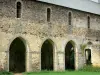
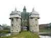
Clairmont Abbey
| Municipality | Saint-Ouën-des-Toits |
|---|---|
| Postcode | 53410 |
| Tourism label | ") |
| Latitude | 48.1422910 (N 48° 8’ 32”) |
| Longitude | -0.8968970 (W 0° 53’ 49”) |
| Altitude | From 118m to 181m |
| Surface area | 21.26 km² |
| Population | 1821 inhabitants |
| Density | 85 inhabitants/km² |
| Prefecture | Laval (13.4 km, 19 min) |
| Insee code | 53243 |
| Intercommunality | CA Laval Agglomération |
| Department | Mayenne |
| Territory | Maine |
| Region | Pays de la Loire |
| Olivet | 3.1 km (5 min) |
|---|---|
| La Baconnière | 6.3 km (10 min) |
| Le Bourgneuf-la-Forêt | 7.6 km (10 min) |
| Port-Brillet | 8.5 km (12 min) |
| Le Genest-Saint-Isle | 8.8 km (10 min) |
| Saint-Germain-le-Fouilloux | 9.5 km (14 min) |
| Loiron-Ruillé | 10.9 km (13 min) |
| Andouillé | 10.9 km (12 min) |
| Changé | 11.7 km (15 min) |
| La Brûlatte | 11.9 km (14 min) |
| Saint-Berthevin | 13.3 km (17 min) |
| Launay-Villiers | 13.9 km (16 min) |
| Chailland | 14.3 km (13 min) |
| Montflours | 14.6 km (17 min) |
| Saint-Germain-le-Guillaume | 14.7 km (15 min) |
| Leisure centres | |
|---|---|
| Natural sites |
| Last name | Outing type | Difficulty | Duration | Departure municipality |
|---|---|---|---|---|
 | Village visit | Easy | 2:00 | La Roche-Neuville (30 km) |
 | Hike | Easy | 1:45 | Prée-d'Anjou (33 km) |
 | Cycling itinerary | Intermediate | 5:00 | Soucé (40 km) |
 | Hike | Intermediate | 2:10 | La Bouëxière (40 km) |
 | Hike | Intermediate | 3:00 | Piré-Chancé (42 km) |