


Favourite
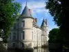
Haroué Castle
| Municipality | Thorey-Lyautey |
|---|---|
| Postcode | 54115 |
| Tourism label | ") |
| Latitude | 48.4427049 (N 48° 26’ 34”) |
| Longitude | 6.0305090 (E 6° 1’ 50”) |
| Altitude | From 274m to 357m |
| Surface area | 6.19 km² |
| Population | 137 inhabitants |
| Density | 22 inhabitants/km² |
| Prefecture | Nancy (35 km, 39 min) |
| Insee code | 54522 |
| Intercommunality | CC du Pays du Saintois |
| Department | Meurthe-et-Moselle |
| Territory | Lorraine |
| Region | Great East |
| Dommarie-Eulmont | 1.6 km (3 min) |
|---|---|
| Étreval | 2.9 km (7 min) |
| Laloeuf | 3.1 km (5 min) |
| Vandeléville | 4.1 km (7 min) |
| Chaouilley | 4.1 km (9 min) |
| Vaudémont | 4.5 km (10 min) |
| Gélaucourt | 5.3 km (9 min) |
| Saxon-Sion | 5.5 km (10 min) |
| Battigny | 6.1 km (8 min) |
| They-sous-Vaudemont | 6.1 km (10 min) |
| Gugney | 6.7 km (10 min) |
| Praye | 6.8 km (12 min) |
| Forcelles-Saint-Gorgon | 7 km (14 min) |
| Vroncourt | 7.1 km (12 min) |
| Ognéville | 7.2 km (8 min) |
| Last name | Activity type | Rate | City |
|---|---|---|---|
 | Local flavours | Free | Sorcy-Saint-Martin (42 km) |
| Last name | Outing type | Difficulty | Duration | Departure municipality |
|---|---|---|---|---|
 | Hike | Easy | 7:35 | Vaudémont (4.7 km) |
 | Hike | Intermediate | 5:00 | Charmes (20 km) |
 | Hike | Intermediate | 3:20 | Maxey-sur-Meuse (25 km) |
 | Hike | Easy | 1:55 | Neufchâteau (26 km) |
 | Hike | Easy | 1:30 | Vigneulles (26 km) |