(D) From the car park, go down on the towpath and go to the right due east. The path borders old slate quarries currently overgrown with vegetation.
Shortly after the children's games, on the right, a natural fountain called "Feunteun ar C'hafé" was recently restored. 50 m further on, still on the right, a small wash house has been fitted out with a small water jet activated by a bicycle as well as waterfalls turning small reels.
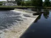
(1) Continue on the wide path to pass the Saint-Algon lock.
(2) About 200 m later, on the right, a log staircase followed by a wide path gives access to a beautiful covered alley at about 150 m.
Return to the backhaul and continue along this path dominated by woods. About 2 km further, reach the second lock, that of Vuzit.
(3) Continue along the backhaul. Ignore a wide stony path that climbs up on your right. Moreover, a small trunk bars the passage. Then ignore a second path starting quickly on the right and skirting a small wood.
Continue until you meet two signs: one prohibiting access to motorized vehicles and the other an old sign for this circuit "Circuit de Pont-Coblant". We will find this old sign from time to time.
(4) Go up on the right by the path, initially between meadows then on the edge of fields to reach a small road just before the hamlet of Keriok. Turn right on this road and then right again to cross the hamlet of Keriok where you can see beautiful restorations of houses (5).
Find the road and continue to the right. Go past the Boullen farm then turn left (old sign) (6). Continue this uphill road and pass Croaz Kerven where you can find a small cross hidden by vegetation on your left.
(7) Join the D41 at Croaz an Toull and turn right. You are in the main street of the village of Gouézec. After the first houses, at a road sign "end of limitation at 70", locate on the right a marker marked Yellow-Orange. Follow this old road for about a hundred meters, cross the main street to find the same marker opposite.
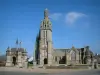
Go past the small calvary "Croaz ar Bleon 1750" then walk along the 16th century Saint-Pierre church where you can see a beautiful restored cross in the enclosure. Pass the cemetery and continue to follow the main street, taking the passage on the right for pedestrians and bicycles.
Continue leaving a housing estate on the right and at a public works workshop HTP (8), turn right at the gable of a blue house in a dead end towards Gomoal.
(9) Before the farm (old sign), turn left into a wide downhill path. Follow it straight ahead then, before the Lesmez farm, turn left into a grassy path (old sign) (10). This trail runs along a wooded wetland and ends in fields.
At the old sign, turn right to go up a wide path between two fields and come to a small road.
(11) Facing the old sign, turn left to go down to Pont-Coblant and join the D785 (12). Turn right then right again at the entrance to the bridge to find the car park.
You pass in front of a former quarry room converted into a chapel in 1951 under the name of Chapelle Sainte-Barbe (explanatory panel).
Waypoints:
D / A: km 0 - alt. 29 m - Parking near the playground.
1: km 0.99 - alt. 41 m - Saint-Algon lock.
2: km 1.2 - alt. 34 m - Bifurcartion (covered driveway).
3: km 3.14 - alt. 41 m - Lock of Vuzid.
4: km 4.48 - alt. 30 m - Path to the right to leave the banks of the Aulne.
5: km 5.05 - alt. 65 m - Passage through the hamlet of Keriok.
6: km 6.02 - alt. 90 m - Turn left.
7: km 7.2 - alt. 111 m - Right at the D41.
8: km 8.79 - alt. 77 m - Atelier HTP, turn right.
9: km 9.09 - alt. 66 m - Path on the left.
10: km 9.76 - alt. 49 m - Grass path on the left.
11: km 10.68 - alt. 52 m - On the left, small road towards Pont-Coblant.
12: km 11.37 - alt. 30 m - D785, right towards the bridge.
D / A: km 11.63 - alt. 29 m - Parking near the playground.
Practical information: Toilets at the departure car park and in the village of Gouézec. No real markings but from time to time old signs "Circuit de Pont-Coblant" (indicated each time in the description).
Other possible departure: Bourg de Gouézec, several car parks (school, church, football stadium).
This hike takes place in 3 different parts:
About 4.5 km of flat along the Alder channeled by the back-tow path.
Ascent to the village of Gouézec via small quiet roads.
Descent to Pont-Coblant mainly by wooded paths and paths.
Always be careful and considerate when hiking.