1. Departing from the tourist office at Saint-Pierre-d'Entremont, follow the marked route: Le pont du lac via Chemin des Mules. Follow the Chambéry road north. 50 meters after the Guiers vive bridge, at the level of a small fountain, take the road on the right.
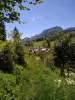
2. Locate the chapel of the 10,000 martyrs, of which only the facade remains, and leave the tarmacked road to follow the chemin des Mules on the left. The path continues in the forest, deviating somewhat from the road to the Col du Granier, and runs along some pastures before descending to the small hamlet Chez Joubert. Then go up to skirt a vast meadow occupied by a typical Carthusian barn. At the intersection, go down to the left towards Chemin des Mules. Cross a small bridge and join the road at the hamlet of Pont du Lac. Follow the road towards Les Couriers / Épernay for about 100 meters, until a crossroads.
3. Take the road that goes up on the left to the hamlet of Courriers. At the entrance to the hamlet, between the basin and the bread oven, take the path to the left as far as the hamlet of La Fracette. Burned down in 1870, then rebuilt by the Carthusians, with tiles made in Saint-Même, it has kept its traditional cachet, in the Carthusian style.
4. Past the last houses, take the road to the right to find, after two hairpin bends, the banks of the Cozon, which you follow to the village.