

Favourite
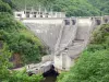
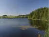
Lake Triouzoune
| Municipality | Arches |
|---|---|
| Postcode | 15200 |
| Latitude | 45.3077560 (N 45° 18’ 28”) |
| Longitude | 2.3277300 (E 2° 19’ 40”) |
| Altitude | From 321m to 687m |
| Surface area | 16.15 km² |
| Population | 199 inhabitants |
| Density | 12 inhabitants/km² |
| Prefecture | Aurillac (61 km, 1:03) |
| Insee code | 15010 |
| Intercommunality | CC du Pays de Mauriac |
| Department | Cantal |
| Territories | Auvergne, Massif Central |
| Region | Auvergne-Rhône-Alps |
| Sourniac | 4 km (7 min) |
|---|---|
| Jaleyrac | 8.9 km (16 min) |
| Le Vigean | 10.3 km (14 min) |
| Mauriac | 12 km (18 min) |
| Chalvignac | 14.5 km (21 min) |
| Bassignac | 17.3 km (20 min) |
| Salins | 17.5 km (22 min) |
| Anglards-de-Salers | 18.3 km (25 min) |
| Veyrières | 19.2 km (26 min) |
| Sérandon | 21 km (30 min) |
| Ydes | 22 km (24 min) |
| Latronche | 22 km (31 min) |
| Brageac | 23 km (37 min) |
| Sauvat | 23 km (31 min) |
| Last name | Activity type | Rate | City |
|---|---|---|---|
 | Sports sensations | 20 € | Lanobre (21 km) |
 | Nature and the great outdoors | 40 € to 75 € | Albepierre-Bredons (47 km) |
| Last name | Outing type | Difficulty | Duration | Departure municipality |
|---|---|---|---|---|
 | Hike | Intermediate | 2:00 | Veyrières (4.9 km) |
 | Village visit | Easy | 1:00 | Fontanges (26 km) |
 | Hike | Intermediate | 2:30 | Saint-Genès-Champespe (33 km) |
 | Hike | Easy | 2:15 | Argentat-sur-Dordogne (39 km) |
 | Hike | Easy | 40 min | Argentat-sur-Dordogne (39 km) |