

Favourite
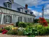
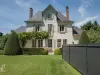
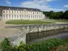
Champ de Bataille Castle
| Municipality | Épégard |
|---|---|
| Postcode | 27110 |
| Tourism label | ") |
| Latitude | 49.1796570 (N 49° 10’ 47”) |
| Longitude | 0.8760970 (E 0° 52’ 34”) |
| Altitude | From 131m to 148m |
| Surface area | 4.41 km² |
| Population | 543 inhabitants |
| Density | 123 inhabitants/km² |
| Prefecture | Evreux (29 km, 33 min) |
| Insee code | 27219 |
| Intercommunality | CC du Pays du Neubourg |
| Department | Eure |
| Region | Normandy |
| Vitot | 3 km (5 min) |
|---|---|
| La Pyle | 3.2 km (9 min) |
| Sainte-Opportune-du-Bosc | 4.1 km (7 min) |
| Le Troncq | 4.3 km (11 min) |
| Le Neubourg | 4.9 km (6 min) |
| Rouge-Perriers | 5.7 km (10 min) |
| Le Bosc du Theil | 6.1 km (7 min) |
| La Neuville-du-Bosc | 6.2 km (9 min) |
| Saint-Meslin-du-Bosc | 6.4 km (8 min) |
| Épreville-près-le-Neubourg | 6.6 km (9 min) |
| Iville | 6.7 km (10 min) |
| Crosville-la-Vieille | 6.7 km (11 min) |
| Villez-sur-le-Neubourg | 7.8 km (10 min) |
| Le Tremblay-Omonville | 8 km (10 min) |
| Last name | Activity type | Rate | City |
|---|---|---|---|
 | Entertainment | 40 € | Sotteville-lès-Rouen (31 km) |
 | Local flavours | 55 € | Saint-Philbert-des-Champs (43 km) |
| Last name | Outing type | Difficulty | Duration | Departure municipality |
|---|---|---|---|---|
 | Hike | Intermediate | 1:10 | Orival (18.6 km) |
 | Cycling itinerary | Athletic | 2:05 | La Bouille (19.4 km) |
 | Hike | Easy | 35 min | Orival (19.6 km) |
 | Hike | Intermediate | 1:55 | Orival (19.6 km) |
 | Hike | Athletic | 3:45 | Sahurs (19.8 km) |