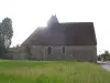
Liven up your holidays!

La Vieille-Lyre

Tourism, holidays & weekends guide in the Eure

La Vieille-Lyre - Tourism, holidays & weekends guide in the Eure
7.2
2

Champignolles:

Long common least populated Eure, Champignolles is a small village that appears as the archetype of Normandy with its picturesque landscapes, wide valley, pastures, old buildings and farms. Located on the edge of the Risle, this miraculously preserved village has an exceptional set of landscaped and natural areas that make it the most beautiful gateway to the Risle Valley.

Geographical information

MunicipalityLa Vieille-Lyre
Postcode27330
Tourism label
Latitude48.9175270 (N 48° 55’ 3”)
Longitude0.7489340 (E 0° 44’ 56”)
AltitudeFrom 127m to 187m
Surface area19.63 km²
Population682 inhabitants
Density34 inhabitants/km²
PrefectureEvreux (34 km, 37 min)
Insee code27685
IntercommunalityCC Interco Normandie Sud Eure
DepartmentEure
RegionNormandy

Nearest cities & towns

La Neuve-Lyre1.2 km (3 min)
Bois-Normand-près-Lyre5.2 km (6 min)
Bois-Anzeray5.9 km (8 min)
Neaufles-Auvergny6.6 km (7 min)
Le Fidelaire6.8 km (8 min)
Les Baux-de-Breteuil7.5 km (10 min)
La Ferrière-sur-Risle8 km (13 min)
Ambenay9.7 km (9 min)
Les Bottereaux9.7 km (12 min)
Sébécourt9.9 km (13 min)
Le Lesme10.2 km (13 min)
La Houssaye10.6 km (17 min)
Rugles11.8 km (12 min)
Le Noyer-en-Ouche12.4 km (20 min)

Things to see and do

Champignolles:

Places of interest

Monuments

Photos

Champignolles
Champignolles
See photo
Champignolles - Saint-Gilles Church Saint-Loup
See photo

Weather

Friday 24 may
Min. 11°C - Max. 16°C
Day
Night
Saturday 25 may
Min. 9°C - Max. 20°C
Day
Night
Sunday 26 may
Min. 12°C - Max. 18°C
Day
Night

Visits, leisure and activities nearby

Leisure activities

Last nameActivity typeRateCity
Cookery lessons at La Maison du Chef Normand
Local flavours55 € Saint-Philbert-des-Champs (47 km)
Telemark water skiing at the Fontaine Simon site
Sports sensations22 € to 75 € Fontaine-Simon (49 km)

Outings

Last nameOuting typeDifficultyDurationDeparture municipality
Way of the Three Calvaries
HikeEasy3:00Asnières (40 km)
Medieval legacy in the Val de Risle
Cycling itineraryEasy4:00Montfort-sur-Risle (42 km)
Hiking in Mouettes
HikeEasy2:50Mouettes (45 km)
Saracens Path
HikeEasy3:00Condé-sur-Risle (45 km)
The Oppidum Trail
HikeIntermediate1:10Orival (49 km)

Restaurants

Bed & breakfasts

Vacation rentals

Campsites

Hotels

Your holidays
A hotel
A vacation rental
A bed & breakfast
A campsite
A leisure activity
A restaurant
A rental car
A plane ticket
By continuing to browse our site, you are agreeing to the use of cookies to improve your experience and make targeted offers.
Find out more and make settings
Your account