
Favourite
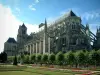
Bourges
| Municipality | Le Subdray |
|---|---|
| Postcode | 18570 |
| Tourism label | ") |
| Latitude | 47.0108050 (N 47° 0’ 39”) |
| Longitude | 2.2941420 (E 2° 17’ 39”) |
| Altitude | From 137m to 169m |
| Surface area | 20.28 km² |
| Population | 1194 inhabitants |
| Density | 58 inhabitants/km² |
| Prefecture | Bourges (13.1 km, 17 min) |
| Insee code | 18255 |
| Intercommunality | CA Bourges Plus |
| Department | Cher |
| Territory | Berry |
| Region | Centre-Loire Valley |
| Morthomiers | 4.8 km (11 min) |
|---|---|
| Trouy | 5.2 km (7 min) |
| Saint-Florent-sur-Cher | 5.2 km (9 min) |
| Saint-Caprais | 5.3 km (8 min) |
| La Chapelle-Saint-Ursin | 8.7 km (11 min) |
| Villeneuve-sur-Cher | 9.4 km (11 min) |
| Lunery | 9.8 km (13 min) |
| Lapan | 11.2 km (14 min) |
| Civray | 11.8 km (16 min) |
| Arçay | 12.4 km (15 min) |
| Lissay-Lochy | 13.1 km (16 min) |
| Bourges | 13.2 km (15 min) |
| Primelles | 13.8 km (20 min) |
| Plaimpied-Givaudins | 13.8 km (18 min) |
| Saint-Doulchard | 15.4 km (15 min) |
| Last name | Activity type | Rate | City |
|---|---|---|---|
 | Entertainment | 75 € to 120 € | Issoudun (24 km) |
| Last name | Outing type | Difficulty | Duration | Departure municipality |
|---|---|---|---|---|
 | Hike | Easy | 2:00 | Quincy (17.1 km) |
 | Village visit | Easy | 2:00 | Mennetou-sur-Cher (43 km) |
| Cycling itinerary | Easy | 2:00 | Saint-Satur (56 km) |