Liven up your holidays!

Montaudin

Tourism, holidays & weekends guide in the Mayenne

Geographical information

MunicipalityMontaudin
Postcode53220
Latitude48.3852950 (N 48° 23’ 7”)
Longitude-0.9894600 (W 0° 59’ 22”)
AltitudeFrom 150m to 227m
Surface area21.66 km²
Population924 inhabitants
Density42 inhabitants/km²
PrefectureLaval (41 km, 46 min)
Insee code53154
IntercommunalityCC du Bocage Mayennais
DepartmentMayenne
TerritoryMaine
RegionPays de la Loire

Nearest cities & towns

Larchamp3.2 km (7 min)
Saint-Berthevin-la-Tannière6.3 km (9 min)
Saint-Mars-sur-la-Futaie6.6 km (7 min)
Saint-Ellier-du-Maine7 km (8 min)
La Dorée7.8 km (8 min)
Levaré8.6 km (10 min)
Le Loroux8.7 km (8 min)
Pontmain10.1 km (10 min)
La Pellerine10.5 km (16 min)
Fougerolles-du-Plessis11.1 km (12 min)
Ernée11.1 km (12 min)
Landivy11.8 km (11 min)
Saint-Denis-de-Gastines12.4 km (18 min)
Carelles12.8 km (15 min)

Things to see and do

Places of interest

Monuments

Weather

Tuesday 4 june
Min. 11°C - Max. 20°C
Day
Night
Wednesday 5 june
Min. 12°C - Max. 19°C
Day
Night
Thursday 6 june
Min. 9°C - Max. 17°C
Day
Night

Visits, leisure and activities nearby

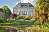
Renaudies gardens, floral park at Colombiers du Plessis.

Amusement park in the Colmont Gorron. Adventure park, swin-golf, mini-rafting ...

Hiking the jump-to-wolf Brecé near Gorron. Interpretive trail around the heritage and nature. 7, 12, 13, 15, 20 km.

Leisure activities

Last nameActivity typeRateCity
Rival'karting
Sports sensations16 € to 24 € Le Neufbourg (32 km)
Flight over Mont Saint-Michel Bay by Ultralight Trike or Autogyro – 20 mins
Sports sensations100 € Le Val-Saint-Père (43 km)
Flight over Mont Saint-Michel Bay on Ultralight Trike or Autogyro – 30 mins
Sports sensations140 € Le Val-Saint-Père (43 km)
Private spa in a tropical environment
Well-being60 € to 150 € Bagnoles de l'Orne Normandie (46 km)

Outings

Last nameOuting typeDifficultyDurationDeparture municipality
Around Lande Pourrie
Car itineraryEasy4:00Saint-Cyr-du-Bailleul (24 km)
Pays Domfrontais
Cycling itineraryIntermediate5:00Soucé (25 km)
Variant of GR 22 by Brécey
HikeEasy3:15Reffuveille (36 km)
La Bouëxière: Chevré Pond
HikeIntermediate2:10La Bouëxière (40 km)
Ercé by Liffré: The Rotes of the Huguenots
HikeIntermediate2:00Ercé-près-Liffré (42 km)

Restaurants

Bed & breakfasts

Vacation rentals

Campsites

Hotels

Your holidays
A hotel
A vacation rental
A bed & breakfast
A campsite
A leisure activity
A restaurant
A rental car
A plane ticket
By continuing to browse our site, you are agreeing to the use of cookies to improve your experience and make targeted offers.
Find out more and make settings
Your account