
Once upon a time Saint-Hernin…
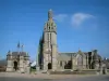
Name of a town, but originally the name of a hermit! Even today we still know very little about this Saint who lived as a hermit who came from Ireland to these lands.
According to the stories, Hernin was described as a man in search of solitude, like many others. The lord of the place granted him "As much land to build his hermitage as he could enclose with ditches in one day". Hernin then took his stick and dragged it for two kilometers around the chosen place.
As the stick passed, the earth piled up and formed a slope, what used to be called a ditch. Hernin lived on these lands alone, he died there around 535, and his body was buried in his hermitage.
After his death, pilgrims flocked to the hermit's tomb to venerate his relics, a bone from his head and a piece of humerus, preserved in two silver reliquaries.
Traces of life on Saint-Hernin have been observed since at least the Bronze Age since some Tumuli (feudal motte) attest to the presence of men and women permanently on the territory with the discovery of vestiges pottery and other everyday objects…
In the Middle Ages, Kergoat Castle was one of the symbols of the power of Saint-Hernin at that time. It has been repeatedly attacked, burned and rebuilt, but unfortunately today it is no more. Some remains such as the surrounding wall, two remarkable dovecotes are still there at a place called Kergoat (private property).
A. Marteville and P. Varin passing through Saint-Hernin around 1845 wrote this to describe Saint-Hernin: "This town, rich in pastures, has a pleasant aspect and forms a happy contrast with those around Carhaix".
In the village's past, the slate quarries played a major economic role for the town. Today, the farms are no more, and the town draws its economic activity from agriculture and agrifood mainly. In the village of Kermanac'h, the remains of an old slate quarry still remain (private property).
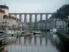
Saint-Hernin is nestled between the Black Mountains (Menez Du in Breton) and the Nantes-Brest canal.
The Black Mountains are a relatively narrow, low-lying mountain range. This mountain range stretches from west to east from around Châteaulin to around Glomel in the Côtes-d'Armor. At Saint-Hernin, the highest peak "Ty Coz" rises 308 meters above sea level. Beautiful hikes are possible on the mountainous part of the town or along the Nantes-Brest canal... Almost 360 kilometers long, the canal crosses inland Brittany. It is located 1.5 km from the town of Saint-Hernin. You can get there by road or by marked hiking trails from the town. Peaceful and bucolic place, it offers the possibility of making beautiful walks along the banks on the towpath.
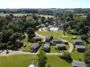
In terms of vegetation, forests, moors and peat bogs cover the Montagnes Noires. The lower you go in altitude, the more agriculture takes over with vast fields separated by embankments. The embankments help retain soil nutrients (phosphorus, etc.). With the limitation of the runoff of water not retained by the plants, the embankment makes it possible to regulate the flow of the channel and the streams during floods, its role is therefore very important!
On the banks of the canal, you can try to see all kinds of animal species (European otter, red squirrel, many birds such as herons, egrets, storks, common buzzards, the marsh harrier, the kestrel, the tawny owl and many others)… The canal also concentrates a wide variety of plant species. But this environment is very fragile, so in order not to frighten the fauna and degrade the flora, please respect the pedestrian and equestrian paths, the cycle paths, limit noise and throw your waste in the garbage cans.
")