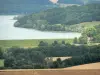

Departure: Place de Faverolles - Marking: blue and yellow - Walking time: 2h - Duration mountain bike: 1h - easy level - Leave towards Rolampont by the D 256. After the last house on the left, take a small road on the right then the first grass trail on the right to the Combe Renard. Many deer can be seen here in autumn and winter. Along the Combe Renard, always going up in foot of cliffs. Join the D 155 which is followed on the left for nearly 500 meters then turn right at the crossroads. Then follow on the left the perimeter of the commune of Beauchemin. During the first 500 meters the middle is quite humid. The trail winds between a beech forest on the right and an oak grove on the left. Go to the D 155 road that crosses to engage in the Bois de Vaubrien. We will soon find the source of the brook Vaubrien, Fontaine du Saut. This stream has the particularity of forming deposits of tuffs by its successive cascades to the Tufière de Rolampont. It flows in a small valley which presents a great ecological interest, faunistic and floristic. It is a protected natural area classified among the sites that constitute the European NATURA 2000 network under the Habitats Directive. On the right side of the North slope, there is a maple grouse with specific centipede on the Langres plateau in areas exposed to the north. The nature of the soil differs in this place where one evolves between two geological layers: marls at the level of the creek and a layer of very hard limestone which forms numerous boulders which can constitute cliffs of 20 meters of height. Then we go back on the plateau. Before the junction with the circuit of the Tufière de Rolampont, we can see an abandoned meadow with some grasses: it is an open environment but which closes gradually, colonized by the forest. If you want to discover the Tufière de Rolampont site, you can follow the circuit of the same name. Otherwise, turn left to return to Faverolles and the museum of the remains of the great mausoleum by the ancient Roman road. Here we find traces of human life dating back at least to the Gallic period. It can not be proved, but it is thought that the lands where the forest is today were used for cultivation: the soil being shallow, it facilitated the cultivation with the rudimentary tools of the time. The remains of shelters are numerous: walls of stones "mounted" during cliffs. This sector was conducive to the development of safe human activities. Today, the forest has replaced crops; it is quite diversified: oak-charmaia, maples-sycamore, lime trees, fruit-trees in the valley. All the tourist info on
Langres