Liven up your holidays!
Destination
State your preferences
Guide
Plan your stay
Your account
English
Français
Deutsch
Italiano
Español
Nederlands
Português
Русский
简体中文
日本語
0
0
0
Occitanie
Menu
Tourism
Gastronomy
Outings
Activities
Events
Restaurants
Hotels
Vacation rentals
Bed & breakfasts
Campsites
Holiday insurance
Rental car
Train tickets
Plane tickets
Transfers
Holiday insurance
Holiday insurance
French courses
Romantic weekend
Family weekend
Cheap weekend
Unusual weekend
Find my position
Confirm
Discover
Tourist sites
Gastronomy
Cities & towns
Tourism labels
Themed itineraries
Custom itineraries
Photos
Panoramas
Tourism quiz
Going out
Leisure activities
Outings
Events
Restaurants
Stay
Hotels
Bed & breakfasts
Vacation rentals
Campsites
Travel
Rental car
Train tickets
Plane tickets
Holiday insurance
Information sheets
French courses
Outings
Occitanie
Outings in Occitanie
Ideas for walks and hikes in Occitanie
Search
Cancel
223
outings found
Occitanie
Change
Sort by difficulty
Sort by change in altitude
Sort by duration
Sort by length in kilometres
Filter results
Open map
Outing type
Hike
Cycling itinerary
Horse ride
Other means of transport
Difficulty
Easy
Intermediate
Athletic
Change in altitude
Less than 200 m
from 200 m to 500 m
from 500 m to 1000 m
More than 1000 m
Duration
Less than 2 h
from 2 h to 4 h
More than 4 h
Kilometres
Less than 5 km
from 5 km to 10 km
from 10 km to 20 km
More than 20 km
Territory
Gascony
Languedoc-Roussillon
Massif Central
Midi-Pyrénées
Pyrenees
Quercy
Filter results
Hide filters
Open map
Hide map
Outings in Occitanie
8.5
3
Cycling itinerary in Valence
Easy
1:50, 29 km (change in altitude 311m)
Favourite
Itinerary
8.8
2
All-terrain bike itinerary in Boudou
Intermediate
1:50, 27 km (change in altitude 182m)
Favourite
Itinerary
8.7
5
All-terrain bike itinerary in Valence
Intermediate
6:45, 96 km (change in altitude 1078m)
Favourite
Itinerary
9.5
6
Cycling itinerary in Villefranche-de-Panat
Intermediate
50 min, 12 km (change in altitude 152m)
Favourite
Itinerary
9.5
6
Cycling itinerary in Vézins-de-Lévézou
Athletic
2:35, 37 km (change in altitude 869m)
Favourite
Itinerary
9.3
6
Cycling itinerary in Salles-Curan
Intermediate
1:45, 27 km (change in altitude 442m)
Favourite
Itinerary
9.1
5
Hike in Gasques
Easy
2:40, 8 km (change in altitude 252m)
Favourite
Itinerary
7.9
3
All-terrain bike itinerary in Sévérac d'Aveyron
Easy
2:40, 35 km (change in altitude 711m)
Favourite
Itinerary
In the Sigean scrubland
7.5
5
Hike in Sigean
Easy
2:00, 6 km (change in altitude 30m)
Hiking edge pond through the viewpoint and a 360 ° perspective, back through the scrub and large Sigean of saline.
Favourite
Itinerary
On the Roman road
7.7
6
Hike in Caudiès-de-Fenouillèdes
Easy
4:00, 6 km (change in altitude 85m)
This walk on the GR 36 and the old Roman road will make you discover the chapel Notre-Dame de Laval, the ruins of the castle of Castel Fizel and Castel Sabarda, as well as the gorges of Saint Jaume.
Favourite
Itinerary
Around Caudiès-de-Fenouillèdes
9.0
4
Hike in Caudiès-de-Fenouillèdes
Easy
1:00, 4 km (change in altitude 0m)
Discover the landscapes that surround the village of Caudiès-de-Fenouillèdes.
Favourite
Itinerary
9.2
5
All-terrain bike itinerary in Moissac
Intermediate
1:50, 27 km (change in altitude 226m)
Favourite
Itinerary
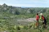
The Flag (Le Drapeau)
8.1
12
Hike in Amélie-les-Bains-Palalda
Intermediate
2:00, 4 km (change in altitude 200m)
This hike goes along the Mondony Gorges and offers beautiful panoramic views of the town. Along the way you can also glimpse the old fort at Amélie-les-Bains as well as the Canigou massif.
Favourite
Itinerary
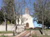
Chapel of Santa Engracia
8.8
16
Hike in Amélie-les-Bains-Palalda
Intermediate
3:30, 8 km (change in altitude 430m)
The Chapel of Santa Engracia stands in the hills around the town of Amélie-les-Bains, near Montalba. There is an orientation table behind the chapel.
Favourite
Itinerary
Lake Aignan
7.2
8
Hike in Aignan
Easy
1:40, 5 km (change in altitude 18m)
Departing from Lake Aignan, this walk through the woodland will take you to see pigeon hunters’ huts, views of the countryside and village, and the Pyrenees too.
Favourite
Itinerary
Felluns from the dolmens to the aqueduct
6.0
5
Hike in Feilluns
Intermediate
5:40, 19 km (change in altitude 400m)
A very varied hike: dolmens, vines, picturesque villages, rivers, Roman aqueduct, orientation tables, rock, old medieval tollhouse, ruined castle, forest and a small cliff.
Favourite
Itinerary
Dolmens walk
6.0
10
Hike in Barjac
Easy
1:45, 8 km (change in altitude 0m)
Amid the woods and scrubland, set off to explore the dolmens in the woods of Barjac. No particular difficulties, gradual inclines.
Favourite
Itinerary
Saint-Ferréol hermitage
8.0
12
Hike in Céret
Easy
2:10, 10 km (change in altitude 85m)
Walk among the cherry orchards then uphill to Saint-Ferréol hermitage, with panoramic views over Vallespir and the Canigou massif!
Favourite
Itinerary
Along the Bohère Canal
7.8
8
Hike in Prades
Intermediate
2:30, 15 km (change in altitude 90m)
A lovely walk to the Abbey of St Michael of Cuxa. It’s uphill at first but after 20 minutes, you reach the Bohère Canal, walking under the trees to the abbey below.
Favourite
Itinerary
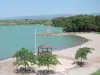
Lake Jouarres
7.6
21
Hike in Olonzac
Easy
1:30, 5 km (change in altitude 0m)
Easy walk. Lake with artificial beach, supervised in the summer, water sports in season (windsurfing, sailint, etc.), Canal du Midi and water sports centre close by.
Favourite
Itinerary
The Arasses
8.0
1
Village visit in Villefranche-de-Panat
Easy
2:00, 4 km (change in altitude 67m)
A stroll along the trails and paths linking La Besse and Villefranche-de-Panat. It will delight young and old.
Favourite
Itinerary
7.7
6
Hike in Saint-Guilhem-le-Désert
Easy
7:55, 16 km (change in altitude 1536m)
Favourite
Itinerary
Around Malepeyre
7.8
5
Hike in Capdenac-Gare
Easy
1:30, 4 km (change in altitude 50m)
Small easy walk with a low gradient (rising Verdier) on a path of earth and stones. You can contemplate the valley of Saint-Julien in Capdenac High, from the Cross of Verdier. Thank you to respect nature. Good ride!
Favourite
Itinerary
Serres of Blaquererie
8.5
4
Hike in La Couvertoirade
Easy
4:00, 25 km (change in altitude 100m)
A hike in the heart of the town of La Couvertoirade, where you will discover a landscape caussenard, vestiges of the past (rock shelters, cazelles dry stone walls and enclosures, caussenardes farms with their traditional architecture), a kind…
Favourite
Itinerary
7.1
6
Hike in Sainte-Marie-la-Mer
Intermediate
3:00, 10 km (change in altitude 170m)
Favourite
Itinerary
Outings
1
2
3
4
5
6
>>
See more results
By continuing to browse our site, you are agreeing to the use of cookies to improve your experience and make targeted offers.
Find out more and make settings
Close
Your account
Continue with my email