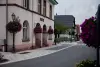
The town is located at an average altitude of 135 m above sea level. It is part of the district of Haguenau-Wissembourg and township of Brumath.
Origin of the name of the city: the German Gerhard anthroponym or Germanic GRIOS (shore sand).
Patron Saint: Saint Jacques.
The Lower Zorn Community of Communes is located in the department of Bas-Rhin and the Greater East region. It consists of seven towns: Bietlenheim, Geudertheim Gries, Hœrdt, Kurtzenhouse Weitbruch and Weyersheim, for a total population of over 17 000 inhabitants.
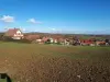
Gries and the village disappeared Wilre: It's on old alluvial sand that was more or less disappeared from the village located "Wilre", at an average altitude of 133 m. Since 1937, we studied the site of the village. A few thousand medieval objects were harvested at the soil surface. From these medieval finds, Wilre is, according to the cadastral map of 1923 the municipality of Gries in section 38 at a place called "In den Weilergärten", extending over an area measuring about 250 meters west and is at least 150 m from north to south. But unmistakable evidence of the existence of a village disappeared in these places was provided during the digging of a trench straight from east to west, 1 m wide, which, over a length of 212 m approximately, cut of houses or huts bases. These buildings are remnants, according to the cadastral map of 1929, in Section 38, at a place called "In der Stallmatt" and in Section 39, at a place called "In den Weilergärten" immediately to the is the former tile Heusch between the local road-Kurtzenhouse Bischwiller and rural road Märzgasse said.
The name "Gries": The old chapel of Gries: During excavations on both sides of the road Gries-Marienthal, 5 mound, ie burial mounds have been updated as well a thirty objects and tools from the Neolithic period (age of polished stone), all exposed to the historical museum of Haguenau. These findings prove that men have lived in the region long before the first document dated March 13, 826, citing first the village as the "Gerareshusa". In 830, the same village is called "Gerireshusa". According to the pastor Guggenbühl, this name comes from the name "Gerhard." The village's name would be: "Gerhardshausen", which suggests that it was the property of a "Gerhard" character whose identity has not yet been discovered. In a document of 974, we already read the "Grioz" more similar to the current name of the village. How to understand this change? The Guggenbühl pastor explained as follows: soon the suffix "hausen" from "Gerireshausen" was abandoned, giving "Gerires" word transformed over the years into "Grioz" then "GRIEZ" and finally in "Gries". It categorically rejects the idea that would derive the name of the village of German words by the presence of sandy land Gries. Similarly he denies the thesis that "grioz" would be composed of the Celtic word "created", meaning earth and "have" location.
The coat of arms of Gries: For several years, the Gries blazon with thrushes and blackbirds was used by mistake. The Department has commissioned further research on the arms of Commons, after which some adjustments were made, including those of Gries. According to armorial, blazon must be the "gold three sand cranes each holding in its claws a mouths of vigilance."
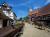
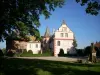
Wars: Ownership of Landgraves Lower Alsace until 1332, the city passed then to Lichtenberg and then the two-Bitche Ponts before belonging to Hanau-Lichtenberg who introduced the Reformation, the village became a Protestant. In 1622 Gries was totally destroyed by the troops of Mansfeld during the Thirty Years War, but the inhabitants took refuge in Strasbourg. Three embedded force Gries... Then, Swiss emigrants have settled in the town. The Hesse-Darmstadt were the last masters of the village from 1736 until the Revolution. They significantly contributed to its development. Southeast of the village is a mound, the only witness of an ancient castle, residence of the bishop of Strasbourg, which remains occupied until the late fifteenth century, a period of destruction. Since the last war, Gries has gradually lost its agricultural character for development of its residential function.
")