Signy-le-Petit is a commune in the Ardennes, in the Grand Est region, 40 km north-west of Charleville-Mezieres, on the edge of the Aisne and Belgium.
The vast territory of 38 km² belongs to the natural region of Thiérache, west of the Ardennes and the Meuse valley, known for its landscape of groves and hilly terrain.
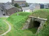
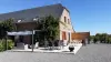
Founded in the 13th century, the village of Signy-le-Petit has suffered for a long time from its border position and wars have not spared it. Burned in the 14th century, ravaged in 1521 and then in 1636, it retained until the 19th century an essentially agricultural vocation. After the establishment of breweries, mills and brick factories, the town is transformed when foundries are installed that modify the geography of the town (creation of ponds, development of rivers) and its sociology (population and housing workers).
This small industry has now disappeared. The village and its nearly 1300 inhabitants have retained a craft, commercial and agricultural activity complemented by tourism thanks to a green environment (forests) and highlighted (leisure base). Labeled "green station", Signy-le-Petit is worth the detour.
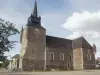
In terms of historical heritage, the impressive St. Nicholas Church must be visited. It dates from 1680, rebuilt after the previous building was burned by Spanish troops which explains its appearance: the fortified church is part of the military architecture. Presenting a form of Latin cross on the inside, on the outside, the walls are 3 meters thick and built of schist. It has a tower porch and multiple defensive elements (watchtowers, machicolations).
In another area, outside the village, the rock of the white stone table-shaped with a cavity filled with water once known as "miraculous" and the way of the cross between the hamlets of Antheny and Gland, from the 13th century, are also worth a look.
These sites mark out a marked path of discovery of the territory.
However, it is its rich natural environment that has become the primary asset of the municipality.
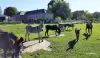
Adjoining the Ardennes Massif, the vast forest of 310 hectares is planted with equal parts of softwood (spruce, pine) and hardwood (oak, beech, birch, hornbeam). The flora and fauna (deer, wild boars, lips, foxes, squirrels, jays, thrushes) are very well developed.
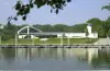
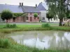
Created during the development of metallurgy, the ponds are numerous in the municipality. That of La Forge (6 hectares), that of Gland (8 hectares), the name of the river whose waters were diverted for its food and that of La Motte (6 hectares) are the most important.
At the latter level, a public recreation base has been developed. Swimming is supervised in summer at the edge of a sandy beach. A fitness trail, picnic areas and games are available. Free access.
Fishing is also allowed, in the ponds as well as along the rivers crossing the locality. Information on +33 3 24 37 50 61.
The base of the Pond Motte, which includes a campsite, is finally the starting point for many hiking including forest areas. Maps and information on +33 3 24 54 20 06.
On the same site, an area of outdoor and private leisure hotel is located. Visitors can find a water park with fun equipment and a mini golf, paid access. Information on +33 3 24 53 54 73.
To enjoy the privileged natural setting of the town and its surroundings, one can also opt for a ride on horseback. Join the Signy Equestrian Farm on +33 3 24 53 11 25.
The hilly landscapes of the Thiérache are also crossed by pleasant little roads that can be driven behind the wheel of venerable 2CV restored, rented by a company based in the town. Information on +33 6 11 96 02 54.
Finally, always in terms of sports and recreation, tennis courts, a sports ground and a petanque are available to tourists and visitors in the village. Information on +33 3 24 53 51 01.