La Chambre is a locality in the Savoie region Auvergne-Rhône-Alpes, 38 km southeast of Chambery and 10 km northwest of Saint-Jean-de-Maurienne.
The small municipal area (3.2 km²) enjoys a privileged geographical location, on the strategic axis Lyon-Turin, in the valley of the Arc, at the foot of the passes of La Madeleine and Glandon, at an altitude varying from 419 to 760 m.
The locality is named after the family of La Chambre, who owned these lands in fiefdom in the Middle Ages, and whose elders passed on the title of Viscount Maurienne. Their missing castle was located on a nearby parish.
The activity at La Chambre was for a long time essentially agricultural but from the beginning of the 20th century, industrial units of the chemical sector were established along the railway line which borders the right bank of the Arc, to the south of the town. It remains today a solvent factory. This activity does not affect the environment of the town, also famous for its dairy specializing in the production of Beaufort cheese.
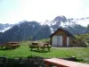
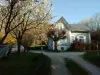
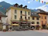
At the foot of the mountains, the historical and natural heritage of La Chambre, village of about 1170 inhabitants animated, justifies a stage, near the major winter sports resorts... and summer.
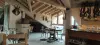
In terms of historical heritage, the town has several assets. This is the case of the former convent of the Cordeliers erected in 1365 by the lord of La Chambre who had obtained the agreement of the pope. It then replaced a Benedictine priory founded in the 11th century. The building which is the subject of a restoration campaign still has beautiful doors and ogival windows of character. All information for a possible visit to the association of friends of the convent on +33 6 84 09 23 13.
We will continue with the collegiate church of Saint-Marcel, the former church of the Assumption erected as a collegiate church in 1514. The building has a portal in sculpted alabaster from the 13th century, that is to say from the end of the Romanesque period, which was reused during the restorations carried out in 1688. This element is now listed. The Flamboyant Gothic facade dates from the 14th century. Inside, we will also notice the capitals with plant motifs or evoking a bestiary with more or less human faces. To see again, a historiated capital framed by two others mixing foliage and grimacing monsters or other ornamentations depicting biblical scenes. It is noted that several lords of La Chambre were buried in this church. Visits to the collegiate church are scheduled on Thursday mornings in July and August. Outside these dates, contact the town hall on +33 4 79 56 20 09.
Finally, a former stronghold of the lords of La Chambre, known as the Maison de la Tour, consisting of a 13th and 14th century tower and a 18th century dwelling now houses the Academy of Maurienne. This institution aims to preserve and enhance the regional heritage in all its forms. Exhibitions and conferences are regularly scheduled, as well as "historic walks". Contact on +33 6 84 09 23 13.
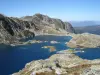
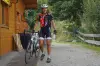
From an environmental point of view, hikes from the territory allow you to start climbing towards the neighboring peaks or to follow the banks of the Arc. Brochures and information on +33 4 79 56 33 58.
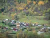
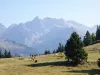
Note that some circuits include meadows where dairy cows are raised. The opportunity to stop over at the La Chambre Dairy Cooperative, which produces and refines Beaufort AOP, also nicknamed the prince of Gruyères. Guided tour followed by a tasting on registration on +33 4 79 56 00 90.
In terms of sport and leisure, a bowling alley and a city park are available to visitors. To reserve a tennis court, contact the local club on +33 9 52 41 94 11.
A club also welcomes tourists who wish to learn about the pleasures of climbing and canyoning under the supervision of experienced instructors. Information on +33 6 77 81 05 73.
Finally, fishing enthusiasts can indulge in their favorite pastime. Join the local association on +33 6 60 29 10 24 to find out which sites are suitable and which regulations to follow.
")