La Tour-en-Maurienne is a common Savoie region Auvergne-Rhône-Alpes, northeast of Saint-Jean-de-Maurienne which it borders.
It was established in January 1, 2019 following the merger of localities Hermillon, its seat (569 inhabitants), Le Châtel (195 inhabitants) and Pontamafrey-Montpascal (318 inhabitants), the latter two villages have already merged in 2001. the new community thus has about 1,100 inhabitants.
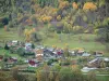
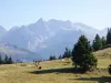
The territory of La Tour-en-Maurienne, wide almost 41 square kilometers, is located in the heart of the Maurienne valley, on the banks of the Bow River (a tributary of the Isere). The main habitat is located some 450 meters above sea level but a village, Montpascal is located at 1400 m altitude on the south side of a chain between the Maurienne and Tarentaise.
Other peaks, the Pointe du Vallon (or Pierced Rock), to over 2,700 m dominate Hermillon east or Grand Corner overlooking the village of Chatel.
Certainly influenced by the proximity of Saint-Jean-de-Maurienne, the villages now associates have developed in the Middle Ages, considered strategic points but also the soils conducive to an average of farming or high mountain (alpine).
More recently, in the twentieth century, the history of the town of Hermillon was marked by two major events: the village was burned by the Germans in 1944, and on a completely different level, the implementation of a plant aluminum into powder to the construction, cosmetics or pyrotechnics.
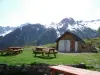
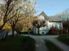
Heritage, exceptional environment, quality of recreation (hiking, Nordic skiing) and near major ski resorts make the new common La Tour-en-Maurienne a welcome step.
The different entities that make up the town each have different strengths in terms of wealth and leisure.
On Hermillon, become a residential community adjacent to the city of Saint-Jean-de-Maurienne (7800 inhabitants), we appreciate the roofs slate features of the area but 1944 the fire has not been without consequence alas Heritage. However, have been preserved chapel Montandré (which dates back to the twelfth), and which was the subject of pilgrimages, the remains of the keep of the Tower of La Clusaz, or the former spa of the Baths of Echaillon, which operated reputable water for their energizing properties (it is now an annex of the hospital of Saint-Jean-de-Maurienne).
On the environmental front, several attractions worth a visit: the cascade of Hermillon, the last parcels of vines on the hillsides leading to Le Châtel and especially the planted areas of natural tulips on the rocky plateau Montandré-like steppes. Once abundant in Maurienne, these red tulips are among the last in the region.
On the same site, next to the chapel, walkers enjoy views overlooking the valley. A viewpoint is installed there.
Information +33 4 79 64 27 72.
Le Chatel, once crossed by a Roman road, to see in terms of heritage, Castle Hermillon (which therefore not on the eponymous village), also known as Tower or Tour de Châtel Berold. This imposing square tower 14.50 m side defensive virtues dated eleventh and was next to a stately home then became the seat of a lordship. The Tower now overlooks the Church of Our Lady of the Annunciation.
Another landmark, the former stronghold of Villaret (XIII), whose tower is in ruins, and which demonstrates again that the axis of the valley was decidedly strategic and very guarded.
On the village again, the nature trail Plagnes allows hikers to admire many orchids.
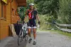
Finally, it is at the top of Chaussy neck that is the northern area of the Grand Corner at 1300 m altitude. In a wooded setting, this plateau has in the winter cross-country skiing tracks (a total of 40 km of two loops starting and Bonvillard Montaimont stations). But we also practiced snowshoeing and a biathlon course is laid out there. In summer, mountain bikers take over. Price for Nordic skiing: 4 or 7.50 euros. Possibility to rent equipment on site. Information +33 4 79 59 47 93 or +33 4 79 64 41 40.
Finally, Pontamafrey-Montpascal, the visitor is confronted with a part in a valley village (Pontamafrey) and secondly to a mountain village (Montpascal) to 1400 m altitude.
In the first, the baroque church rebuilt in the late sixteenth after the wars of religion deserves the glance as well as the chapel of the Immaculate Conception, on the left bank of the Arc, built in the rock in 1859 after a subscription with the locals. She became the emblem of the small community.
Another chapel, dedicated to St. Benedict, date of 1700. The altar and most of the paintings were made in 1852 and it houses a painting of the Spanish painter Pignol (1763).
On Montpascal, St. Michael's Church from the early eighteenth century. Chaussy The chapel dates from the same period but was rebuilt in 1892. It houses a wooden statue depicting the Visitation dated 1644.
On the civilian side, finally, on the edge of the Arc, there is still a medieval fort.
Regarding leisure "nature", Pontamafrey-Montpascal has earned a reputation for its climbing and via ferrata built on granite cliffs.
For these activities, as with all opportunities for hiking or mountain biking in the area, including the villages but obviously their steep slopes and surroundings as natural sites of interest, maps and information +33 4 79 83 51 51.
")