Liven up your holidays!

Orelle

Tourism, holidays & weekends guide in the Savoie

Orelle - Tourism, holidays & weekends guide in the Savoie
7.8
6

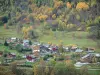
Orelle, a traditional village located in Maurienne, is connected to the 3 Valleys ski area: 600 km of slopes, the largest ski area in the world.

In summer, Orelle becomes the ideal spot for cycle tourists thanks to its geographical location in the heart of the Maurienne valley, at the crossroads of the great Alpine passes: Iseran, Mont-Cenis, Galibier...

Geographical information

MunicipalityOrelle
Postcode73140
Tourism label
Latitude45.2100320 (N 45° 12’ 36”)
Longitude6.5340710 (E 6° 32’ 3”)
AltitudeFrom 819m to 3400m
Surface area69.25 km²
Population326 inhabitants
Density4 inhabitants/km²
PrefectureChambéry (93 km, 1:02)
Insee code73194
IntercommunalityCC Maurienne Galibier
DepartmentSavoie
TerritoryAlps
RegionAuvergne-Rhône-Alps

Nearest cities & towns

Saint-Michel-de-Maurienne6.4 km (9 min)
Saint-Martin-d'Arc6.6 km (10 min)
Freney8.2 km (10 min)
Saint-Martin-de-la-Porte9.3 km (16 min)
Saint-André9.4 km (12 min)
Fourneaux10 km (12 min)
Modane12.2 km (16 min)
Saint-Julien-Mont-Denis14 km (18 min)
Villarodin-Bourget14.9 km (21 min)
Montricher-Albanne15.6 km (20 min)
Avrieux16.7 km (22 min)
La Norma17 km (23 min)
Valmeinier17.4 km (27 min)
Villargondran18.7 km (23 min)
Aussois19.3 km (26 min)

Things to see and do

Baroque church of Saint-Maurice, capital of Orelle.

Traditional hamlets, wash houses, bread ovens, village squares.

Winter activities: sliding activities, ice waterfalls, walks, snowshoeing, zip line...

Winter/summer activities: excursions in Italy, visit to the farm.

Summer activities: heritage visits, hiking, climbing, mountain biking, summer opening of the gondola 1 day per week.

Places of interest

Information points
Leisure centres
Natural sites

Photos

Hamlet of the capital
See photo
La Mauriennaise
La Mauriennaise
See photo
Hameau de Bonvillard
See photo
Igloos Village
Igloos Village
See photo
Cré Fenère orientation table
See photo
Refuge des Marches
Refuge des Marches
See photo

Weather

Thursday 23 may
Min. 1°C - Max. 16°C
Day
Night
Friday 24 may
Min. 0°C - Max. 6°C
Day
Night
Saturday 25 may
Min. 0°C - Max. 7°C
Day
Night

Visits, leisure and activities nearby

Via ferrata, hiking framed, canyoning, rafting, glacier walking ...

Leisure activities

Last nameActivity typeRateCity
Guided hike in Haute Maurienne Vanoise
Nature and the great outdoors15 € to 230 € Val-Cenis (19.7 km)
Tailor-made photo shoot
Arts and Crafts120 € to 190 € Villarembert (20 km)
Refuges Sentinelles long-distance science hike
Culture and education585 € Villar-d'Arêne (24 km)
Family rafting course in the Isère gorges
Sports sensations62 € Aime-la-Plagne (36 km)
Rafting on the Doron de Bozel
Sports sensations88 € Aime-la-Plagne (36 km)

Outings

Last nameOuting typeDifficultyDurationDeparture municipality
Valloirette Fitness Trail
HikeEasy2:00Valloire (9.6 km)
Poingt Ravier Eco-Forest Trail
HikeEasy2:30Valloire (9.8 km)
Trekking from Aussois Dams to Parrachée Dent Hut
HikeEasy2:30Aussois (15.7 km)
The Aussois Background, dams at the refuge
HikeEasy1:45Aussois (15.7 km)
Forest sculpture trail
HikeEasy2:30Aussois (16.4 km)

Restaurants

Bed & breakfasts

Vacation rentals

Campsites

Hotels

Your holidays
A hotel
A vacation rental
A bed & breakfast
A campsite
A leisure activity
A restaurant
A rental car
A plane ticket
By continuing to browse our site, you are agreeing to the use of cookies to improve your experience and make targeted offers.
Find out more and make settings
Your account